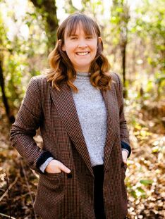
I’m a researcher and mapmaker at Dartmouth College and I work at the intersections of mapping and feminist theory. In my work, I apply feminist principles across spatial data, map design, and mapping processes to reveal and challenge systems of power, privilege, and oppression. This often takes place in collaborative workshop settings. I have applied this feminist mapping lens to migration stories, border symbolization, tiny map icons, incarceration and policing, the climate crises, and housing insecurity. meghankelly-cartography.github.io
|
Wednesday March 3 @ 12PM AZ/2PM EST
In this workshop, I will introduce a feminist mapping framework that can be applied to spatial data, map design, and mapping workflows. I’ll illustrate seven feminist principles within this framework through a series of examples. Next, we will collectively explore the feminist mapping framework through a series of hands-on sketch mapping activities. First, we will examine iconography and logos used by public information campaigns (PIC) for border enforcement. We will then iteratively redesign the PIC icons and logos with the feminist mapping framework guiding our sketches. Second, we will examine existing maps of PIC, border enforcement, and migration data before sketching alternative design solutions that center the feminist mapping framework. Throughout this workshop, we will uncover the possibilities for feminist mapping with real-world data while reflecting on our own positions as mapmakers.
|
|
Global Intimate Body Mapping
Dominica Whitesell, Doctoral Candidate in the Department of Geography at the University of Texas at Austin Suggested Prerequisites: Open to all skill levels Tools: Paper and colored markers/pens 
My name is Dominica and I am a feminist geographer studying the gendered and colonial dimensions of neoliberal urban development via the secondhand clothing industry in Kampala, Uganda. My work weaves together feminist political and economic Geography, postcolonial and African urban theory, and critical cartography frameworks to map the everyday experiences and spatial encounters of women traders in Kampala. Following feminist global intimate and mutiscalar assertions, I argue that centering women’s daily lives offers insight into the intimate, lived, and material spatial realities of power and makes visible the ways in which women navigate and disrupt urban processes. I am particularly inspired by feminist, Black, and other critical cartography interventions and approaches which have made room for more plural, playful, and participatory expressions of space. article: global intimate mapping approaches
https://universityoftexas.wixsite.com/dominicawhitesell |
Thursday March 11 @ 2PM AZ/4PM EST
Drawing from feminist and critical cartography approaches, in this workshop I will lead us through a set global intimate body-mapping exercises. Foregrounding embodied, visceral, and emotional experiences of space, in these activities we will quite literally flip the map, thinking through spatial formations as they are felt and manifested on the body. Following body-mapping frameworks developed by Sweet and Escalante (2015), we will have participants reflect on how our built environments shape our bodily experiences and conversely, how bodies make material spatial and political processes. Here we will outline our bodies and add symbols, drawings, buildings, spaces, words, stories, and/or sounds inside and outside of the outline to showcase our varied spatial experiences. I find this type of mapping deeply provocative not only because it prompts us to visually represent embodiment and intimate scales of analysis in new ways, but also because it inherently calls into question mapping conventions, cartographic norms, and what gets to constitute a map. Through these activities I will speak to the continued debates and concerns of feminist, Black, and postcolonial cartographers and offer insight into the many ways in which maps and mapping practices are being reimagined and creatively remade.
|
|
Collaborative Comics as Critical Feminist Research Writing
Kacy McKinney, PhD, Instructor of Urban Studies and Planning, Portland State University Suggested Prerequisites: Participants do not need to have drawing or comics skills! Tools: It would be helpful for to have a ready means for drawing (pencil or pen and paper or post-it notes) and to scan (photograph and upload) images to share with the group. 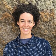
Kacy McKinney is a critical feminist geographer and visual artist. She is an instructional faculty member focused on the undergraduate major in Community Development at Portland State University, bringing international perspectives into the study of community development. Her past research has focused on the relationship between technological and agricultural change, and labor migration and land rights in Brazil and India. Her current research is focused on using comics to change the narrative on houselessness through collaborative ethnographic cartooning. She has also used comics as an approach to feminist visualization in her teaching and research writing. In Portland, Dr. McKinney is currently serving as the chair of the board of directors of Sisters of the Road, a non-profit organization working to create systemic change to end poverty and homelessness by providing nourishing meals in a safe, dignified space.
"Changing the Narrative Around Student Homelessness Through Ethnographic Cartooning" Research Articles/Publications Website |
Tuesday March 16 @ 1030AM AZ/130PM EST
In this workshop, I will introduce the form and creation of comics as an approach to critical feminist visualization in research writing and reporting. First, I will share the research process and design for our current project, Changing the Narrative Around Student Homelessness Through Ethnographic Cartooning. Our interview-based research seeks to document stories of Portland State students who have experienced homelessness or housing instability through collaboration with Portland-based comic artists and two community organization partners. I will also share examples from comics journalism and an ethnographic cartooning project that is a key source of inspiration for my research team: El Viaje Más Caro (The Most Costly Journey), which is focused on the experiences of Latin American migrant farm workers in the dairy industry in Vermont. Second, I will introduce the language of comics and ways of understanding the space and place of comics and their uses for the visualization of data. In the second half of the workshop, I will walk us through a practice round of short interviews leading into collaborative storyboarding. This workshop will illustrate how the form of comics and the approach of collaborative cartooning can be used to share research findings in ways that are accessible, approachable, critically feminist, anti-racist, and that work to provide counter narratives about poverty and homelessness.
|
|
Creating Maps Without GIS
Annita Lucchesi, PhD student at the School of Geography, Development & the Environment at the University of Arizona Suggested Prerequisites: Basic Knowledge of Adobe Illustrator is a plus. Tools: It would be helpful if people downloaded Illustrator and set it up in advance (you can rent it by the month so that the cost isn’t prohibitive). I would also recommend having some art supplies you feel comfortable with set aside and ready. At minimum this should include blank paper and pens or colored pencils, but can include anything else you have that strikes your fancy (scissors, glue, tape, colored paper, feathers, glitter, fabric, yarn, etc). 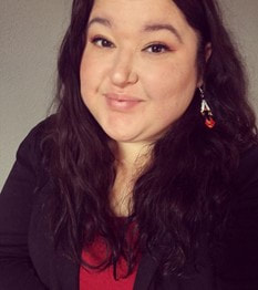
Annita Lucchesi is a Cheyenne cartographer and researcher, currently pursuing a PhD in Geography at the University of Arizona. Her specialities include Indigenous and critical cartographies, feminist data visualization and feminist cartographies, and arts based mapping.
annitalucchesi.com |
Thursday, March 18 @ 1230 PM AZ/ 330 PM EDT
This workshop will explore varying methods of creating maps outside GIS, including mapping in Adobe Illustrator and art-based mapping. This workshop is aimed at empowering participants of all skill levels and access points to be mapmakers and to use maps as compelling forms of data visualization with the full freedom available through mapping outside GIS.
|
